

DanPan
-
Aantal bijdragen
900 -
Geregistreerd
-
Laatst bezocht
-
Gewonnen dagen
10
Soort bijdrage
Profielen
Forums
Kalender
Berichten geplaatst door DanPan
-
-
Maar wat zouden we willen betalen om hem te mogen plaatsen?
€0
-
Release Notes (18 Juni, 2014):
Premium Member Pocket Queries make a leap forward in two words: More and Easier.
- More: Now Premium Members will be able to download twice as many Pocket Queries a day, from 5 to 10 PQ's a day.
- Easier: All PQ's deliver a new custom email with a direct link to download the PQ in one click. Users must be logged into Geocaching.com to download the file directly.
We've also reverted the change from "Unknown" to "Mystery" in GPX files, meaning that "?" caches will display and filter properly in those applications and devices that could not handle the terminology change.
This release also increased performance to a new email system.
-
Ik zou ook graag mijn data base opschonen door gearchiveerde caches te verwijderen,
De te volgen stappen:
0) Search > Cancel Filter
1) Geocaching.com access > Status check > All in current filter > OK
2) Search > Filter > Available status: Archived > Go
3) Waypoint > Delete Waypoint(s) > All waypoints in filter > OK
-
Ik zou enkel nog maar de GSAK db "voeden" met een wekelijkse PQ van nieuwe caches die uitkomen (selecteer op "is enabled" en "placed during the last month") en "my finds" PQ.
Het updaten van status/logs/cachedata van de caches die reeds in je DB zitten, kan je doen via de GSAK menu "Geocaching.com access" (Refresh cache data/Get recent los/Status check)
-
Wij gaan deze zomer in hetzelfde gebied cachen, en willen onder andere deze cache doen! (http://coord.info/GC4K7RR) Heeft iemand nog tips? Tips voor leuke caches daar? Zou deze te doen zijn? We zijn al een bookmarklist aan het maken met caches die we willen doen: http://www.geocaching.com/bookmarks/view.aspx?guid=7b4909dc-68d9-4fc4-9fb0-5bed5140ef27
Puur op basis van % Favorites punten, de caches in een straal van 30 km rond jullie camping en die minstens 10 Favo's hebben: link
En op basis van Wilson score: link
Kwaliteit gewaarborgd!
-
-
Nou danpan, je maakt mij er blij mee

http://gsak.net/help/hs21040.htm geeft een overzichtje van alle GSAK databasevariabelen (beginnen met $d_) die je kan gebruiken.
-
Wat je zou kunnen doen is de attributen toevoegen aan een log bij een export van GSAK naar je GPS.
Hoe:
1) maak gebruik van de GarminExport.gsk
2) In het veld "Custom User Export Macros" kies "AddToFirstLog"
3) Klik op Edit en voeg je code toe:
voorbeeld:
$_Special = $_Special + "*Name: $d_Name" + "<br />" + "*Hints: $d_Hints" + "<br />" + "*UserNote: $d_UserNote" + "<br />" + "*Last Found: $d_LastFoundDate" + "<br />" + "*Placed: " + DateFormat($d_PlacedDate) + "<br />" + "*Favs: $d_FavPoints" + "<br />"  + "*GPX date: " + DateFormat($d_LastGPXDate) + "<br />" +  "*Corr. Coords.: $d_HasCorrected" + "<br />" + "*Height: $d_Elevation m" + "<br />---<br />Waypoints:<br />"
TABLE Active=Waypoints Scope=Parent
While NOT ($_EOL)
    $Data = $d_cLat + " " + $d_cLon
    $Coordinates=GCalc($Data, "FormatMinutes")
    $Coordinates=Replace(";"," ", $Coordinates, TRUE)
    $_Special=$_Special + "<br />" + $d_cPrefix + " - " + $d_cType + "<br />" +  $d_cName  + "<br />" + $Coordinates + "<br />" + "Comments:" + $d_cComment + "<br />" + "<br />"
    GOTO Position=Next
ENDWHILE
TABLE Active=caches
4) Preview output:
Voorbeeld:
5/23/2014, GSAK
*Name: UV Urban Cache
*Hints: NL: Dit is een "terrein puzzel" die je met een beetje gezond boerenverstand kan oplossen. GEEN speciale tool nodig !!
*UserNote:
*Last Found:
*Placed: 30/05/2014
*Favs: 225
*GPX date: 01/06/2014
*Corr. Coords.: False
*Height: 0 m
---
Waypoints:
01 - Virtual Stage
Point A
N 50° 52.206 E 4° 18.574
Comments:A = ?
02 - Virtual Stage
Point B
N 50° 52.254 E 4° 18.619
Comments:B = ?
03 - Virtual Stage
Point C
N 50° 52.275 E 4° 18.533
Comments:C = ?
04 - Virtual Stage
Point D
N 50° 52.206 E 4° 18.548
Comments:D = ?Yes: is field puzzle
Yes: Flashlight required
Yes: UV Light Required
Yes: Special Tool Required
Yes: Wireless Beacon
Yes: Tree Climbing
Yes: May require wadingYes: Takes less than an hour
Yes: Available at all times
Yes: Bicycles
Yes: Parking available
Yes: Dogs
Yes: Recommended for kids
Favorite Points: 225
Premium member Cache
-
Het probleem werd opgelost door Groundspeak!
De caches zijn terug zichtbaar op de Geocaching.com map, alsook de functie "Send to GPS" werkt terug.
-
Het probleem werd opgelost door Groundspeak!
Je kan nu terug caches sturen naar je Garmin GPS vanop de Geocaching.com map
-
Je bent niet de enige, dit probleem is gemeld bij Groundspeak, zie topic
Het probleem wordt wss veroorzaakt doordat de geocaching.com map sinds de laatste update van 13 mei enkel nog maar bereikbaar is via secure connectie HTTPS.
Ik heb ook nog ergens een WinXP met IE8 draaïen en daarop werkt de kaart prima.
Check eens of je nog wel bent ingelogd op geocaching.com. (rechtsbovenaan "You are logged in as ...")
Ter info: wanneer je niet ingelogd bent blijft de kaart sowieso grijs.
-
Opzich zou dit idd een oorzaak kunnen zijn maar waarom het vanaf de cachepagina die hier ook gewoon in https geladen wordt wel werkt?
Omdat een cachepagina geladen wordt in http en niet https...
-
Doordat de pagina http://www.geocaching.com/map secure en niet-secure content bevat, schakelt je browser de URL automatisch naar https://www.geocaching.com/map
Blijkbaar kan de Garmin plugin niet overweg met een secure HTTPS connectie.
Ik heb dit ook laten weten aan Moun10Bike, hopelijk komt er snel een oplossing. (link)Dit probleem is veroorzaakt sinds de update van dinsdag die groundspeak heeft uitgevoerd.
Work-around: gebruik "Send to My GPS" vanop de cachepagina want die werkt nog wel.
-
Je bent niet de enige met dit probleem, zie ook deze topic op het gc.com forum.
Blijkbaar enkel een probleem met de Garmin etrex.
Enkel "Send to My GPS" vanop de cachepagina blijkt nog te werken.
-
Krijgt GC.nl mails over dingen die van GC.com verwijderd moeten worden? Dat is stom...
Zo stom is dat niet. Geocaching.com heeft Engels sprekende medewerkers op 9000km afstand die lastig of niet te bereiken zijn.
Stichting Geocaching Nederland spreekt Nederlands, kan direct adviseren en waar nodig een helpende hand bieden.
Waarom de klacht niet doorspelen aan de reviewers, zij zijn toch de vertegenwoordigers / aanspreekpunten van gc.com?
Zij kunnen dan de CO contacteren en acties nemen.
Ook geocaching.be krijgt maandelijks enkele klachten binnen. Deze sturen we door naar de reviewers en melden aan de "klager" dat we zijn vraag hebben doorgestuurd naar de juiste instanties.
-
 1
1
-
-
Hier kan je de topic i.v.m. het probleem laden van kaarten volgen op het geocaching.com forum.
-
Oeps... er was al een topic over.
Deze topic mag verwijderd worden.
-
Release Notes 25 feb 2014
The latest release of Geocaching.com has lots of goodies, updates and fixes for everyone:
- Ready to start your GeoTour? Now you have the correct phone number.
- Shiny new videos are now on the Geocaching 101 page.
- The Geocaching for Beginners brochure received a fabulous makeover.
- Hiding a geocache is now less of a game of hide, seek and potentially re-hide. There’s a new map to help hiders find likely locations to place geocaches. The map shows a radius around the known locations of traditional geocaches and physical and visible waypoints without revealing their exact location. Hidden waypoints and some additional information are not shown. Geocaches are still reviewed by geocaching community volunteers before they’re published.
- And of course, the ever-present round of bug extermination.
Er is nu een kaart beschikbaar die cirkels (straal 161m) toont van de lokatie van traditionalcaches en fysieke/zichtbare WPs (SoM) van een multicache.
-
Bekijk de pagina eens in "Compatibilty view".
(inschakelen via menu Tools of door klikken op het ikoontje rechts naast de URL balk)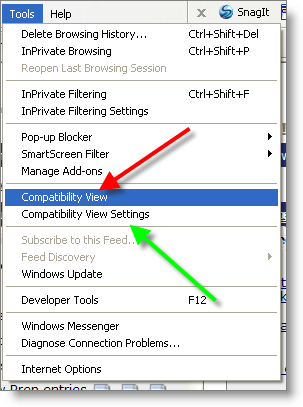

Ofwel heeft het iets te maken met de update die Groundspeak gisteren heeft uitgevoerd. -
In GSAK ga naar menu "Geocaching.com access" > "Get geocaches..."
In Tab Basic: Reference = GCXXXX code en geef in het invoerveld de gc-codes in gescheiden door een komma.
-
Er was een storing van de hardware, mss was dit de oorzaak.
We had a hardware failure that has now been corrected. You should start seeing your missing PQs coming through now. Thanks for your patience!
Er zijn ook meldingen over een trage website.
http://forums.groundspeak.com/GC/index.php?showtopic=319952&view=findpost&p=5353613
Uptime en response tijden van website geocaching.com en geocaching apps kan je hier bekijken. -
Zijn hier ergens statistieken te vinden die laten zien hoeveel nieuwe caches er bij komen per dag ?
In NL worden er per dag tussen de 20 à 30 nieuwe caches gelegd, afhankelijk van het seizoen.
Het aantal nieuwe caches is gedaald met - 25% tov vorig jaar.
Daarentegen het aantal gevonden caches is gestegen met + 25%.
Op project-gc kan je zien hoeveel nieuwe caches er bijkomen de laatste week/maand, vanaf 1 januari en vergelijken met vorig jaar.
Caches verstopt in Nederland....2014....2013.......Verschil
Vorige week......................120.....194......-74....-38%
Vorige maand.....................724.....847.....-123....-15%
Sinds 1 januari.................1086....1440.....-354....-25%
-
-
Het zou handig zijn dat je de HTML code mbt de afbeelding, hier eens post. Dan kunnen we meekijken... Zie ook post #6
Het Mag Wat Kosten, Je Cache Plaatsen.
in Algemene vragen
Geplaatst · bewerkt door DanPan
Als ik een kwalitatieve cache leg, waarom zou ik hiervoor dan €10 moeten betalen voor het plaatsen van de cache?